Thank you for supporting this site ❤️
Make a donation
Make a donation
Gear up for your next adventure:
As an Amazon Associate, this site earns from qualifying purchases at no extra cost to you.
Tranby Park
- Distance: 1.2 mi
- Elevation gain: 13 ft
- Maximum elevation: 594 ft
- Elevation loss: 13 ft
- Minimum elevation: 587 ft
- Moving time: 10 m 27 s
- Moving speed: 6.7 mph
- Maximum speed: 9.4 mph
- Total time: 10 m 27 s
- Global speed: 6.7 mph
Interactive trail map
Thank you for supporting this site ❤️
Make a donation
Make a donation
Gear up for your next adventure:
As an Amazon Associate, this site earns from qualifying purchases at no extra cost to you.
Trail profile
- Distance: 1.2 mi
- Elevation gain: 13 ft
- Maximum elevation: 594 ft
- Elevation loss: 13 ft
- Minimum elevation: 587 ft
- Moving time: 10 m 27 s
- Moving speed: 6.7 mph
- Maximum speed: 9.4 mph
- Total time: 10 m 27 s
- Global speed: 6.7 mph
Thank you for supporting this site ❤️
Make a donation
Make a donation
Gear up for your next adventure:
As an Amazon Associate, this site earns from qualifying purchases at no extra cost to you.
About this trail
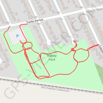
Name: Tranby Park trail, distance, elevation, map, profile, GPS track
Start: Tranby Avenue, Windsor, Ontario, N8S 4R6, Canada (42.32080 -82.94880)
End: Tranby Avenue, Windsor, Ontario, N8S 4R6, Canada (42.32088 -82.94796)
Coordinates: 42.31891 -82.94910 42.32088 -82.94448
Thank you for supporting this site ❤️
Make a donation
Make a donation
Gear up for your next adventure:
As an Amazon Associate, this site earns from qualifying purchases at no extra cost to you.