Thank you for supporting this site ❤️
Make a donation
Make a donation
Gear up for your next adventure:
As an Amazon Associate, this site earns from qualifying purchases at no extra cost to you.
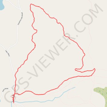
Savanna Portage State Park
Aitkin County Running
- Distance: 3.8 mi
- Elevation gain: 246 ft
- Maximum elevation: 1,404 ft
- Elevation loss: 246 ft
- Minimum elevation: 1,253 ft
- Moving time: 58 m 53 s
- Moving speed: 3.9 mph
- Maximum speed: 8.1 mph
- Total time: 58 m 53 s
- Global speed: 3.9 mph
Interactive trail map
Thank you for supporting this site ❤️
Make a donation
Make a donation
Gear up for your next adventure:
As an Amazon Associate, this site earns from qualifying purchases at no extra cost to you.
Trail profile
- Distance: 3.8 mi
- Elevation gain: 246 ft
- Maximum elevation: 1,404 ft
- Elevation loss: 246 ft
- Minimum elevation: 1,253 ft
- Moving time: 58 m 53 s
- Moving speed: 3.9 mph
- Maximum speed: 8.1 mph
- Total time: 58 m 53 s
- Global speed: 3.9 mph
Thank you for supporting this site ❤️
Make a donation
Make a donation
Gear up for your next adventure:
As an Amazon Associate, this site earns from qualifying purchases at no extra cost to you.
About this trail
Name: Savanna Portage State Park trail, distance, elevation, map, profile, GPS track
Start: Lake Place, Aitkin County, Minnesota, United States (46.82885 -93.17751)
End: Lake Place, Aitkin County, Minnesota, United States (46.82864 -93.17752)
Coordinates: 46.82775 -93.17752 46.84336 -93.15835
Topography: Aitkin County topographic map, elevation, terrain
Thank you for supporting this site ❤️
Make a donation
Make a donation
Gear up for your next adventure:
As an Amazon Associate, this site earns from qualifying purchases at no extra cost to you.