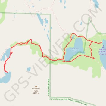
Hike to Middle Conness Lake near Saddlebag Lake
Saddlebag Conness Lakes
- Distance: 4.4 mi
- Elevation gain: 702 ft
- Maximum elevation: 10,692 ft
- Elevation loss: 702 ft
- Minimum elevation: 10,092 ft
- Moving time: 2 h 26 m
- Moving speed: 1.8 mph
- Maximum speed: 3.4 mph
- Total time: 3 h 37 m
- Global speed: 1.2 mph
Interactive trail map
Trail profile
- Distance: 4.4 mi
- Elevation gain: 702 ft
- Maximum elevation: 10,692 ft
- Elevation loss: 702 ft
- Minimum elevation: 10,092 ft
- Moving time: 2 h 26 m
- Moving speed: 1.8 mph
- Maximum speed: 3.4 mph
- Total time: 3 h 37 m
- Global speed: 1.2 mph
About this trail
Name: Hike to Middle Conness Lake near Saddlebag Lake trail, distance, elevation, map, profile, GPS track
Coordinates: 37.97573 -119.30606 37.98260 -119.28431
Topography: Mono County topographic map, elevation, terrain