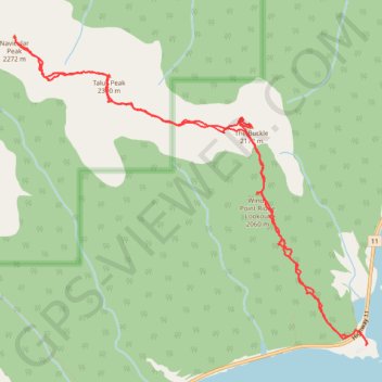
Traverse of Windy Point Ridge via The Buckle, Talus Peak and Navicular Peak
Scrambling, mountain, peak
- Distance: 7.8 mi
- Elevation gain: 4,908 ft
- Maximum elevation: 7,510 ft
- Elevation loss: 4,911 ft
- Minimum elevation: 4,364 ft
- Moving time: 6 h 14 m
- Moving speed: 1.3 mph
- Maximum speed: 3.3 mph
- Total time: 15 h 7 m
- Global speed: 0.5 mph
Interactive trail map
Trail profile
- Distance: 7.8 mi
- Elevation gain: 4,908 ft
- Maximum elevation: 7,510 ft
- Elevation loss: 4,911 ft
- Minimum elevation: 4,364 ft
- Moving time: 6 h 14 m
- Moving speed: 1.3 mph
- Maximum speed: 3.3 mph
- Total time: 15 h 7 m
- Global speed: 0.5 mph
About this trail
Name: Traverse of Windy Point Ridge via The Buckle, Talus Peak and Navicular Peak trail, distance, elevation, map, profile, GPS track
Start: Highway 11, Clearwater County, Alberta, Canada (52.25414 -116.39208)
End: Clearwater County, Alberta, Canada (52.25425 -116.39188)
Coordinates: 52.25414 -116.43784 52.27876 -116.39187