Thank you for supporting this site ❤️
Make a donation
Make a donation
Gear up for your next adventure:
As an Amazon Associate, this site earns from qualifying purchases at no extra cost to you.
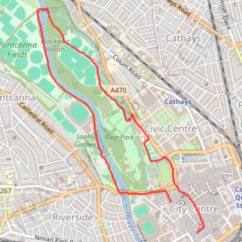
Bute Park Loop
- Distance: 3.3 mi
- Elevation gain: 115 ft
- Maximum elevation: 69 ft
- Elevation loss: 108 ft
- Minimum elevation: 26 ft
- Moving time: 1 h 15 m
- Moving speed: 2.6 mph
- Maximum speed: 10.4 mph
- Total time: 1 h 19 m
- Global speed: 2.5 mph
Interactive trail map
Thank you for supporting this site ❤️
Make a donation
Make a donation
Gear up for your next adventure:
As an Amazon Associate, this site earns from qualifying purchases at no extra cost to you.
Trail profile
- Distance: 3.3 mi
- Elevation gain: 115 ft
- Maximum elevation: 69 ft
- Elevation loss: 108 ft
- Minimum elevation: 26 ft
- Moving time: 1 h 15 m
- Moving speed: 2.6 mph
- Maximum speed: 10.4 mph
- Total time: 1 h 19 m
- Global speed: 2.5 mph
Thank you for supporting this site ❤️
Make a donation
Make a donation
Gear up for your next adventure:
As an Amazon Associate, this site earns from qualifying purchases at no extra cost to you.
About this trail
Name: Bute Park Loop trail, distance, elevation, map, profile, GPS track
Coordinates: 51.47787 -3.19662 51.49546 -3.17564
Thank you for supporting this site ❤️
Make a donation
Make a donation
Gear up for your next adventure:
As an Amazon Associate, this site earns from qualifying purchases at no extra cost to you.