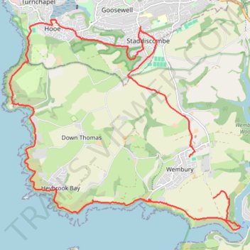
Loop from Wembury in South Devon National Landscape
- Distance: 13.3 mi
- Elevation gain: 2,100 ft
- Maximum elevation: 384 ft
- Elevation loss: 2,106 ft
- Minimum elevation: 0 ft
- Moving time: 6 h 7 m
- Moving speed: 2.2 mph
- Maximum speed: 6.3 mph
- Total time: 7 h 4 m
- Global speed: 1.9 mph
Interactive trail map
Trail profile
- Distance: 13.3 mi
- Elevation gain: 2,100 ft
- Maximum elevation: 384 ft
- Elevation loss: 2,106 ft
- Minimum elevation: 0 ft
- Moving time: 6 h 7 m
- Moving speed: 2.2 mph
- Maximum speed: 6.3 mph
- Total time: 7 h 4 m
- Global speed: 1.9 mph
About this trail
Name: Loop from Wembury in South Devon National Landscape trail, distance, elevation, map, profile, GPS track
Coordinates: 50.31174 -4.12668 50.35424 -4.05356
Other hiking, mountain biking, running and outdoor activity trails
Click on a trail to view its statistics, map and profile.
Wembury ebike ride
United Kingdom > England > Devon > South Hams > Wembury
Distance: 4.5 mi • Elevation gain: 571 ft • Maximum elevation: 364 ft
Mountbatten, Down Thomas
United Kingdom > England > Plymouth
Distance: 8.8 mi • Elevation gain: 1,266 ft • Maximum elevation: 374 ft
Plymouth eBike ride
United Kingdom > England > Plymouth
Distance: 26.9 mi • Elevation gain: 2,618 ft • Maximum elevation: 381 ft