Make a donation
Gear up for your next adventure:
As an Amazon Associate, this site earns from qualifying purchases at no extra cost to you.
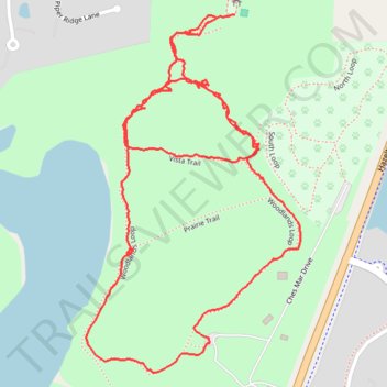
Lake Minnewashta Vista Trail and Woodlands Loop
- Distance: 2.1 mi
- Elevation gain: 112 ft
- Maximum elevation: 1,017 ft
- Elevation loss: 112 ft
- Minimum elevation: 951 ft
Interactive trail map
Make a donation
Gear up for your next adventure:
As an Amazon Associate, this site earns from qualifying purchases at no extra cost to you.
Trail profile
- Distance: 2.1 mi
- Elevation gain: 112 ft
- Maximum elevation: 1,017 ft
- Elevation loss: 112 ft
- Minimum elevation: 951 ft
Make a donation
Gear up for your next adventure:
As an Amazon Associate, this site earns from qualifying purchases at no extra cost to you.
About this trail
Name: Lake Minnewashta Vista Trail and Woodlands Loop trail, distance, elevation, map, profile, GPS track
Coordinates: 44.88087 -93.59108 44.88775 -93.58526
Topography: Carver County topographic map, elevation, terrain
Make a donation
Gear up for your next adventure:
As an Amazon Associate, this site earns from qualifying purchases at no extra cost to you.
Other hiking, mountain biking, running and outdoor activity trails
Click on a trail to view its statistics, map and profile.
Woodlands Loop in Lake Minnewashta Regional Park
United States > Minnesota > Carver County > Chanhassen
Distance: 1.5 mi • Elevation gain: 89 ft • Maximum elevation: 1,017 ft