Make a donation
Gear up for your next adventure:
As an Amazon Associate, this site earns from qualifying purchases at no extra cost to you.
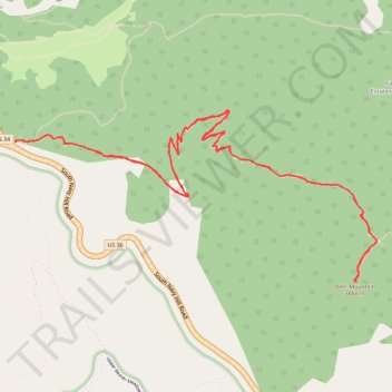
Deer Mountain
Interactive trail map
Make a donation
Gear up for your next adventure:
As an Amazon Associate, this site earns from qualifying purchases at no extra cost to you.
Trail profile
- Distance: 6.0 mi
- Elevation gain: 1,358 ft
- Maximum elevation: 9,964 ft
- Elevation loss: 1,355 ft
- Minimum elevation: 8,911 ft
- Moving time: 2 h 43 m
- Moving speed: 2.2 mph
- Maximum speed: 3.9 mph
- Total time: 3 h 11 m
- Global speed: 1.9 mph
Make a donation
Gear up for your next adventure:
As an Amazon Associate, this site earns from qualifying purchases at no extra cost to you.
About this trail
Name: Deer Mountain trail, distance, elevation, map, profile, GPS track
Start: Deer Mountain Trail, Larimer County, Colorado, United States (40.38712 -105.60978)
End: Deer Mountain Trail, Larimer County, Colorado, United States (40.38713 -105.60981)
Coordinates: 40.37916 -105.60981 40.38896 -105.58270
Topography: Larimer County topographic map, elevation, terrain
Make a donation
Gear up for your next adventure:
As an Amazon Associate, this site earns from qualifying purchases at no extra cost to you.
Other hiking, mountain biking, running and outdoor activity trails
Click on a trail to view its statistics, map and profile.
Deer Mountain Trail in Rocky Mountain National Park
United States > Colorado > Larimer County
The Deer Mountain Trail in Rocky Mountain National Park offers hikers a moderately challenging ascent through serene ponderosa pine forests, leading to panoramic summit views. Along the trail, you'll encounter vistas of Little Horseshoe Park and the Mummy Range, with occasional sightings of local wildlife like…
Distance: 6.1 mi • Elevation gain: 1,411 ft • Maximum elevation: 9,967 ft