Make a donation
Gear up for your next adventure:
As an Amazon Associate, this site earns from qualifying purchases at no extra cost to you.
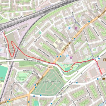
Dalry path up
- Distance: 0.7 mi
- Elevation gain: 82 ft
- Maximum elevation: 246 ft
- Elevation loss: 0 ft
- Minimum elevation: 164 ft
- Moving time: 11 m 25 s
- Moving speed: 3.4 mph
- Maximum speed: 14.9 mph
- Total time: 11 m 25 s
- Global speed: 3.4 mph
Interactive trail map
Make a donation
Gear up for your next adventure:
As an Amazon Associate, this site earns from qualifying purchases at no extra cost to you.
Trail profile
- Distance: 0.7 mi
- Elevation gain: 82 ft
- Maximum elevation: 246 ft
- Elevation loss: 0 ft
- Minimum elevation: 164 ft
- Moving time: 11 m 25 s
- Moving speed: 3.4 mph
- Maximum speed: 14.9 mph
- Total time: 11 m 25 s
- Global speed: 3.4 mph
Make a donation
Gear up for your next adventure:
As an Amazon Associate, this site earns from qualifying purchases at no extra cost to you.
About this trail
Name: Dalry path up trail, distance, elevation, map, profile, GPS track
Start: Russell Road, Dalry, City of Edinburgh, Scotland, EH11 2LS, United Kingdom (55.94291 -3.22894)
Coordinates: 55.94040 -3.22894 55.94291 -3.21854
Make a donation
Gear up for your next adventure:
As an Amazon Associate, this site earns from qualifying purchases at no extra cost to you.
Other hiking, mountain biking, running and outdoor activity trails
Click on a trail to view its statistics, map and profile.
Cycleroute Edinburgh
United Kingdom > Scotland > City of Edinburgh
Summer!
Distance: 47.5 mi • Elevation gain: 2,907 ft • Maximum elevation: 1,066 ft