Make a donation
Gear up for your next adventure:
As an Amazon Associate, this site earns from qualifying purchases at no extra cost to you.
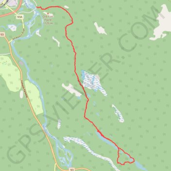
Valley of the 5 Lakes
Interactive trail map
Make a donation
Gear up for your next adventure:
As an Amazon Associate, this site earns from qualifying purchases at no extra cost to you.
Trail profile
- Distance: 12.0 mi
- Elevation gain: 1,545 ft
- Maximum elevation: 3,829 ft
- Elevation loss: 1,562 ft
- Minimum elevation: 3,392 ft
Make a donation
Gear up for your next adventure:
As an Amazon Associate, this site earns from qualifying purchases at no extra cost to you.
About this trail
Name: Valley of the 5 Lakes trail, distance, elevation, map, profile, GPS track
Start: Valley of the 5 Lakes Trail, Municipality of Jasper, Alberta, T0E 1E0, Canada (52.87111 -118.06098)
End: Valley of the 5 Lakes Trail, Municipality of Jasper, Alberta, T0E 1E0, Canada (52.87134 -118.06226)
Coordinates: 52.81370 -118.06226 52.87158 -118.00303
Make a donation
Gear up for your next adventure:
As an Amazon Associate, this site earns from qualifying purchases at no extra cost to you.
Other hiking, mountain biking, running and outdoor activity trails
Click on a trail to view its statistics, map and profile.