Make a donation
Gear up for your next adventure:
As an Amazon Associate, this site earns from qualifying purchases at no extra cost to you.
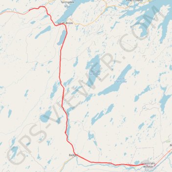
Sheppardville - Grand Falls-Windsor
#Bike #Sheppardville #GrandFalls #Windsor #Newfoundland
- Distance: 63.0 mi
- Elevation gain: 1,857 ft
- Maximum elevation: 659 ft
- Elevation loss: 1,837 ft
- Minimum elevation: 26 ft
Interactive trail map
Make a donation
Gear up for your next adventure:
As an Amazon Associate, this site earns from qualifying purchases at no extra cost to you.
Trail profile
- Distance: 63.0 mi
- Elevation gain: 1,857 ft
- Maximum elevation: 659 ft
- Elevation loss: 1,837 ft
- Minimum elevation: 26 ft
Make a donation
Gear up for your next adventure:
As an Amazon Associate, this site earns from qualifying purchases at no extra cost to you.
About this trail
Name: Sheppardville - Grand Falls-Windsor trail, distance, elevation, map, profile, GPS track
Coordinates: 48.94165 -56.27645 49.48453 -55.67918
Make a donation
Gear up for your next adventure:
As an Amazon Associate, this site earns from qualifying purchases at no extra cost to you.
Other hiking, mountain biking, running and outdoor activity trails
Click on a trail to view its statistics, map and profile.
Grand Falls-Windsor - Gander
Canada > Newfoundland and Labrador > Grand Falls-Windsor
#Bike #GrandFalls #Windsor #Gander #Newfoundland
Distance: 61.2 mi • Elevation gain: 2,293 ft • Maximum elevation: 476 ft