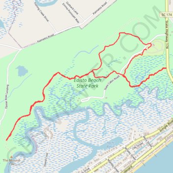
Edisto Beach State Park Loop
Loop hike via Campground Trail, Scott Creek Trail, Big Bay Trail, Spanish Mount Trail and Live Oak in the Edisto Beach State Park. #Hiking #Loop #Nature #Forest #River #Park
- Distance: 4.5 mi
- Elevation gain: 69 ft
- Maximum elevation: 26 ft
- Elevation loss: 69 ft
- Minimum elevation: 3 ft
- Moving time: 1 h 19 m
- Moving speed: 3.4 mph
- Maximum speed: 10.8 mph
- Total time: 1 h 23 m
- Global speed: 3.2 mph
Interactive trail map
Trail profile
- Distance: 4.5 mi
- Elevation gain: 69 ft
- Maximum elevation: 26 ft
- Elevation loss: 69 ft
- Minimum elevation: 3 ft
- Moving time: 1 h 19 m
- Moving speed: 3.4 mph
- Maximum speed: 10.8 mph
- Total time: 1 h 23 m
- Global speed: 3.2 mph
About this trail
Name: Edisto Beach State Park Loop trail, distance, elevation, map, profile, GPS track
Coordinates: 32.50094 -80.32101 32.51301 -80.29972
Topography: Colleton County topographic map, elevation, terrain