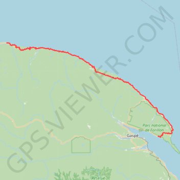
Madeleine - Gaspé
Gulf of Saint Lawrence. #Bike #Madeleine #Gaspé #SaintLawrence #Atlantic
- Distance: 74.6 mi
- Elevation gain: 7,556 ft
- Maximum elevation: 965 ft
- Elevation loss: 7,602 ft
- Minimum elevation: -3 ft
Interactive trail map
Trail profile
- Distance: 74.6 mi
- Elevation gain: 7,556 ft
- Maximum elevation: 965 ft
- Elevation loss: 7,602 ft
- Minimum elevation: -3 ft
About this trail
Name: Madeleine - Gaspé trail, distance, elevation, map, profile, GPS track
Coordinates: 48.82410 -65.34904 49.24924 -64.20270
Other hiking, mountain biking, running and outdoor activity trails
Click on a trail to view its statistics, map and profile.
Gaspé - Saint-Georges-de-Malbaie
Canada > Quebec > La Côte-de-Gaspé > Gaspé > Cap-aux-Os > D'Aiguillon
Forillon National Park. Gulf of Saint Lawrence. #Bike #Gaspé #SaintGeorgesDeMalbaie #Forillon #SaintLawrence #Atlantic
Distance: 47.1 mi • Elevation gain: 2,612 ft • Maximum elevation: 262 ft
Sainte-Anne-des-Monts - Madeleine
Canada > Quebec > La Haute-Gaspésie > Sainte-Anne-des-Monts
Saint Lawrence River. #Bike #SainteAnneDesMonts #Madeleine #SaintLawrence
Distance: 57.5 mi • Elevation gain: 2,841 ft • Maximum elevation: 351 ft