Bramber Castle
- Distance: 8.5 mi
- Elevation gain: 853 ft
- Maximum elevation: 620 ft
- Elevation loss: 850 ft
- Minimum elevation: 0 ft
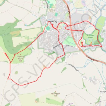
Interactive trail map
Trail profile
- Distance: 8.5 mi
- Elevation gain: 853 ft
- Maximum elevation: 620 ft
- Elevation loss: 850 ft
- Minimum elevation: 0 ft
About this trail
Name: Bramber Castle trail, distance, elevation, map, profile, GPS track
Start: The Street, Bramber, Horsham, West Sussex, England, BN44 3WE, United Kingdom (50.88392 -0.31155)
End: The Street, Bramber, Horsham, West Sussex, England, BN44 3WE, United Kingdom (50.88321 -0.31206)
Coordinates: 50.87135 -0.35235 50.89028 -0.30653
Other hiking, mountain biking, running and outdoor activity trails
Click on a trail to view its statistics, map and profile.
Truleigh Hill and Mile Oak from Steyning and Beeding
United Kingdom > England > West Sussex > Steyning
Distance: 14.3 mi • Elevation gain: 1,621 ft • Maximum elevation: 663 ft
Steyning Bramber
United Kingdom > England > West Sussex > Horsham > Bramber
Distance: 7.3 mi • Elevation gain: 781 ft • Maximum elevation: 591 ft