Make a donation
Gear up for your next adventure:
As an Amazon Associate, this site earns from qualifying purchases at no extra cost to you.
Delicate Arch (Arches National Park)
Hike to Delicate Arch via Delicate Arch Trail in the Arches National Park. #Hiking #Nature #Rock #Park
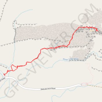
- Distance: 3.4 mi
- Elevation gain: 771 ft
- Maximum elevation: 4,820 ft
- Elevation loss: 768 ft
- Minimum elevation: 4,291 ft
- Moving time: 1 h 25 m
- Moving speed: 2.4 mph
- Maximum speed: 4.1 mph
- Total time: 1 h 48 m
- Global speed: 1.9 mph
Interactive trail map
Make a donation
Gear up for your next adventure:
As an Amazon Associate, this site earns from qualifying purchases at no extra cost to you.
Trail profile
- Distance: 3.4 mi
- Elevation gain: 771 ft
- Maximum elevation: 4,820 ft
- Elevation loss: 768 ft
- Minimum elevation: 4,291 ft
- Moving time: 1 h 25 m
- Moving speed: 2.4 mph
- Maximum speed: 4.1 mph
- Total time: 1 h 48 m
- Global speed: 1.9 mph
Make a donation
Gear up for your next adventure:
As an Amazon Associate, this site earns from qualifying purchases at no extra cost to you.
About this trail
Name: Delicate Arch (Arches National Park) trail, distance, elevation, map, profile, GPS track
Start: Delicate Arch Trail, Grand County, Utah, United States (38.73554 -109.52034)
End: Delicate Arch Trail, Grand County, Utah, United States (38.73606 -109.51985)
Coordinates: 38.73553 -109.52065 38.74431 -109.49881
Topography: Grand County topographic map, elevation, terrain
Make a donation
Gear up for your next adventure:
As an Amazon Associate, this site earns from qualifying purchases at no extra cost to you.
Other hiking, mountain biking, running and outdoor activity trails
Click on a trail to view its statistics, map and profile.
Delicate Arch
United States > Utah > Grand County
Starting at the Delicate Arch Trailhead, the route leaves the parking area near Salt Wash and follows Delicate Arch Trail past the historic Wolfe Ranch area and the nearby Ute Indian petroglyph panel. From there, it heads into open desert terrain, crossing shallow drainages and moving away from the easier…
Distance: 3.2 mi • Elevation gain: 636 ft • Maximum elevation: 4,820 ft
Delicate Arch Trail in Arches National Park
United States > Utah > Grand County
The Delicate Arch Trail offers a rewarding experience, combining a moderately challenging hike with breathtaking scenery. The trail takes you through varied terrain, including stretches of slickrock and a narrow sandstone ridge, leading to the iconic arch perched dramatically above a natural rock bowl. Along…
Distance: 3.1 mi • Elevation gain: 581 ft • Maximum elevation: 4,820 ft
Delicate Arch Trail in Arches National Park
United States > Utah > Grand County
Hiking the Delicate Arch Trail is an unforgettable adventure that takes you through the striking red rock landscape of Arches National Park. The path leads you closer to one of the most recognizable natural arches in the world, and while the final approach can be a bit intimidating with its open slickrock, the…
Distance: 3.2 mi • Elevation gain: 686 ft • Maximum elevation: 4,820 ft