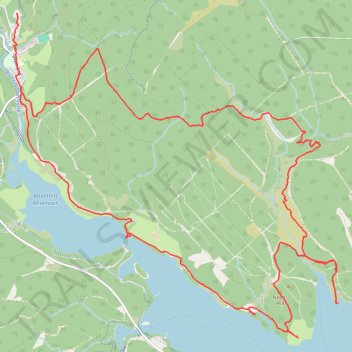
Bakethin Reservoir, Kielder Water and Needs Hill Loop
- Distance: 10.3 mi
- Elevation gain: 1,214 ft
- Maximum elevation: 1,070 ft
- Elevation loss: 1,125 ft
- Minimum elevation: 607 ft
- Moving time: 3 h 1 m
- Moving speed: 3.4 mph
- Maximum speed: 9.2 mph
- Total time: 3 h 24 m
- Global speed: 3.0 mph
Interactive trail map
Trail profile
- Distance: 10.3 mi
- Elevation gain: 1,214 ft
- Maximum elevation: 1,070 ft
- Elevation loss: 1,125 ft
- Minimum elevation: 607 ft
- Moving time: 3 h 1 m
- Moving speed: 3.4 mph
- Maximum speed: 9.2 mph
- Total time: 3 h 24 m
- Global speed: 3.0 mph
About this trail
Name: Bakethin Reservoir, Kielder Water and Needs Hill Loop trail, distance, elevation, map, profile, GPS track
Coordinates: 55.20528 -2.58092 55.23638 -2.52646