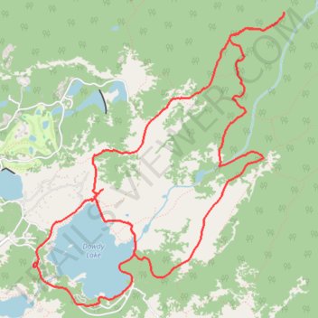
Columbine Ridge and Dowdy Lake loop trail
- Distance: 8.0 mi
- Elevation gain: 666 ft
- Maximum elevation: 8,219 ft
- Elevation loss: 666 ft
- Minimum elevation: 7,812 ft
- Moving time: 1 h 11 m
- Moving speed: 6.7 mph
- Maximum speed: 16.7 mph
- Total time: 1 h 28 m
- Global speed: 5.4 mph
Interactive trail map
Trail profile
- Distance: 8.0 mi
- Elevation gain: 666 ft
- Maximum elevation: 8,219 ft
- Elevation loss: 666 ft
- Minimum elevation: 7,812 ft
- Moving time: 1 h 11 m
- Moving speed: 6.7 mph
- Maximum speed: 16.7 mph
- Total time: 1 h 28 m
- Global speed: 5.4 mph
About this trail
Name: Columbine Ridge and Dowdy Lake loop trail trail, distance, elevation, map, profile, GPS track
Start: Dowdy Lake Road, Larimer County, Colorado, 80545, United States (40.79515 -105.56533)
End: Dowdy Lake Road, Larimer County, Colorado, 80545, United States (40.79510 -105.56539)
Coordinates: 40.79156 -105.56539 40.81756 -105.53603
Topography: Larimer County topographic map, elevation, terrain