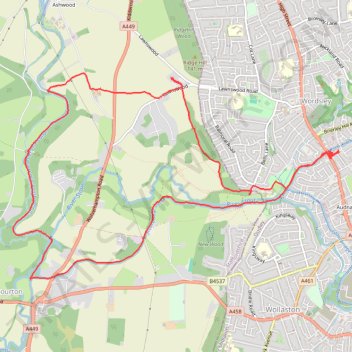
Canal walk public foot paths - Wordsley
- Distance: 8.1 mi
- Elevation gain: 394 ft
- Maximum elevation: 377 ft
- Elevation loss: 394 ft
- Minimum elevation: 177 ft
- Moving time: 2 h 55 m
- Moving speed: 2.8 mph
- Maximum speed: 6.9 mph
- Total time: 3 h 49 m
- Global speed: 2.1 mph
Interactive trail map
Trail profile
- Distance: 8.1 mi
- Elevation gain: 394 ft
- Maximum elevation: 377 ft
- Elevation loss: 394 ft
- Minimum elevation: 177 ft
- Moving time: 2 h 55 m
- Moving speed: 2.8 mph
- Maximum speed: 6.9 mph
- Total time: 3 h 49 m
- Global speed: 2.1 mph
About this trail
Name: Canal walk public foot paths - Wordsley trail, distance, elevation, map, profile, GPS track
Coordinates: 52.46371 -2.20842 52.48397 -2.15577