Make a donation
Gear up for your next adventure:
As an Amazon Associate, this site earns from qualifying purchases at no extra cost to you.
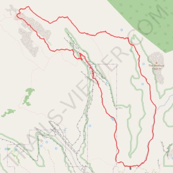
Water Canyon, White Domes and Squirrel Canyon loop in Canaan Mountain Wilderness
- Distance: 10.1 mi
- Elevation gain: 2,710 ft
- Maximum elevation: 6,946 ft
- Elevation loss: 2,720 ft
- Minimum elevation: 5,121 ft
- Moving time: 5 h 5 m
- Moving speed: 2.0 mph
- Maximum speed: 3.8 mph
- Total time: 6 h 27 m
- Global speed: 1.6 mph
Interactive trail map
Make a donation
Gear up for your next adventure:
As an Amazon Associate, this site earns from qualifying purchases at no extra cost to you.
Trail profile
- Distance: 10.1 mi
- Elevation gain: 2,710 ft
- Maximum elevation: 6,946 ft
- Elevation loss: 2,720 ft
- Minimum elevation: 5,121 ft
- Moving time: 5 h 5 m
- Moving speed: 2.0 mph
- Maximum speed: 3.8 mph
- Total time: 6 h 27 m
- Global speed: 1.6 mph
Make a donation
Gear up for your next adventure:
As an Amazon Associate, this site earns from qualifying purchases at no extra cost to you.
About this trail
Name: Water Canyon, White Domes and Squirrel Canyon loop in Canaan Mountain Wilderness trail, distance, elevation, map, profile, GPS track
Start: Water Canyon Road, Hildale, Washington County, Utah, 84784, United States (37.02658 -112.95324)
Coordinates: 37.02535 -112.98406 37.06502 -112.94079
Topography: Washington County topographic map, elevation, terrain
Make a donation
Gear up for your next adventure:
As an Amazon Associate, this site earns from qualifying purchases at no extra cost to you.
Other hiking, mountain biking, running and outdoor activity trails
Click on a trail to view its statistics, map and profile.
Short Creek survey
United States > Utah > Washington County > Hildale
Distance: 8.6 mi • Elevation gain: 1,677 ft • Maximum elevation: 5,666 ft