Thank you for supporting this site ❤️
Make a donation
Make a donation
Gear up for your next adventure:
As an Amazon Associate, this site earns from qualifying purchases at no extra cost to you.
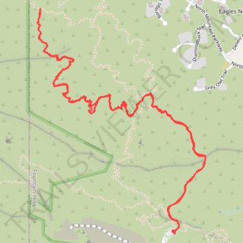
Mesquite Hollow Trail out & back hike - McDowell Mountain Preserve
- Distance: 4.5 mi
- Elevation gain: 1,119 ft
- Maximum elevation: 2,844 ft
- Elevation loss: 1,122 ft
- Minimum elevation: 2,461 ft
- Moving time: 2 h 25 m
- Moving speed: 1.9 mph
- Maximum speed: 3.3 mph
- Total time: 3 h 23 m
- Global speed: 1.3 mph
Interactive trail map
Thank you for supporting this site ❤️
Make a donation
Make a donation
Gear up for your next adventure:
As an Amazon Associate, this site earns from qualifying purchases at no extra cost to you.
Trail profile
- Distance: 4.5 mi
- Elevation gain: 1,119 ft
- Maximum elevation: 2,844 ft
- Elevation loss: 1,122 ft
- Minimum elevation: 2,461 ft
- Moving time: 2 h 25 m
- Moving speed: 1.9 mph
- Maximum speed: 3.3 mph
- Total time: 3 h 23 m
- Global speed: 1.3 mph
Thank you for supporting this site ❤️
Make a donation
Make a donation
Gear up for your next adventure:
As an Amazon Associate, this site earns from qualifying purchases at no extra cost to you.
About this trail
Name: Mesquite Hollow Trail out & back hike - McDowell Mountain Preserve trail, distance, elevation, map, profile, GPS track
Coordinates: 33.62107 -111.78677 33.63477 -111.77442
Topography: Maricopa County topographic map, elevation, terrain
Thank you for supporting this site ❤️
Make a donation
Make a donation
Gear up for your next adventure:
As an Amazon Associate, this site earns from qualifying purchases at no extra cost to you.