Thank you for supporting this site ❤️
Make a donation
Make a donation
Gear up for your next adventure:
As an Amazon Associate, this site earns from qualifying purchases at no extra cost to you.
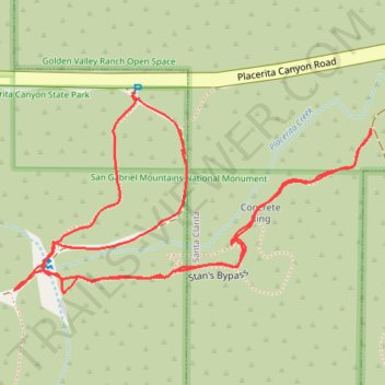
Placerita Canyon/Walker Ranch
- Distance: 1.1 mi
- Elevation gain: 171 ft
- Maximum elevation: 1,906 ft
- Elevation loss: 171 ft
- Minimum elevation: 1,811 ft
- Moving time: 27 m 58 s
- Moving speed: 2.3 mph
- Maximum speed: 4.5 mph
- Total time: 33 m 50 s
- Global speed: 1.9 mph
Interactive trail map
Thank you for supporting this site ❤️
Make a donation
Make a donation
Gear up for your next adventure:
As an Amazon Associate, this site earns from qualifying purchases at no extra cost to you.
Trail profile
- Distance: 1.1 mi
- Elevation gain: 171 ft
- Maximum elevation: 1,906 ft
- Elevation loss: 171 ft
- Minimum elevation: 1,811 ft
- Moving time: 27 m 58 s
- Moving speed: 2.3 mph
- Maximum speed: 4.5 mph
- Total time: 33 m 50 s
- Global speed: 1.9 mph
Thank you for supporting this site ❤️
Make a donation
Make a donation
Gear up for your next adventure:
As an Amazon Associate, this site earns from qualifying purchases at no extra cost to you.
About this trail
Name: Placerita Canyon/Walker Ranch trail, distance, elevation, map, profile, GPS track
Coordinates: 34.37596 -118.44409 34.37803 -118.43967
Topography: Santa Clarita topographic map, elevation, terrain
Thank you for supporting this site ❤️
Make a donation
Make a donation
Gear up for your next adventure:
As an Amazon Associate, this site earns from qualifying purchases at no extra cost to you.