Make a donation
Gear up for your next adventure:
As an Amazon Associate, this site earns from qualifying purchases at no extra cost to you.
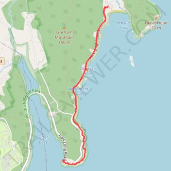
Ocean Path Trail in Acadia National Park
The Ocean Path Trail in Acadia National Park offers hikers a picturesque journey along Maine's rugged coastline, beginning at Sand Beach and culminating at Otter Point. Along this mostly level trail, you'll encounter notable landmarks such as Thunder Hole, where waves crash into a narrow inlet creating resounding booms, and Monument Cove, known for its striking sea stack and pebble beach. The path also provides views of the towering Otter Cliffs and the expansive Atlantic Ocean, making it a must-visit for those seeking coastal scenery. #Hiking #Coast #Sea #Atlantic #Ocean #Cliff #Nature
- Distance: 4.2 mi
- Elevation gain: 499 ft
- Maximum elevation: 108 ft
- Elevation loss: 495 ft
- Minimum elevation: 0 ft
- Moving time: 2 h 2 m
- Moving speed: 2.1 mph
- Maximum speed: 3.8 mph
- Total time: 2 h 14 m
- Global speed: 1.9 mph
Interactive trail map
Make a donation
Gear up for your next adventure:
As an Amazon Associate, this site earns from qualifying purchases at no extra cost to you.
Trail profile
- Distance: 4.2 mi
- Elevation gain: 499 ft
- Maximum elevation: 108 ft
- Elevation loss: 495 ft
- Minimum elevation: 0 ft
- Moving time: 2 h 2 m
- Moving speed: 2.1 mph
- Maximum speed: 3.8 mph
- Total time: 2 h 14 m
- Global speed: 1.9 mph
Make a donation
Gear up for your next adventure:
As an Amazon Associate, this site earns from qualifying purchases at no extra cost to you.
About this trail
Name: Ocean Path Trail in Acadia National Park trail, distance, elevation, map, profile, GPS track
Start: 1254, Park Loop Road, Bar Harbor, Hancock County, Maine, 04609, United States (44.32994 -68.18430)
End: Ocean Path, Bar Harbor, Hancock County, Maine, United States (44.32990 -68.18432)
Coordinates: 44.30694 -68.19353 44.32994 -68.18430
Topography: Hancock County topographic map, elevation, terrain
Make a donation
Gear up for your next adventure:
As an Amazon Associate, this site earns from qualifying purchases at no extra cost to you.
Other hiking, mountain biking, running and outdoor activity trails
Click on a trail to view its statistics, map and profile.
Beehive Trail, Gorham Mountain Trail and Ocean Path Loop in Acadia National Park
United States > Maine > Hancock County > Bar Harbor
The Beehive Trail, Gorham Mountain Trail, and Ocean Path Loop in Acadia National Park offer a diverse and rewarding hiking experience. Starting with the Beehive Trail, hikers ascend a steep path equipped with iron rungs, leading to panoramic views of Sand Beach and the surrounding coastline. Continuing along…
Distance: 3.7 mi • Elevation gain: 814 ft • Maximum elevation: 492 ft
Loop hike via The Beehive, The Bowl, Gorham Mountain and Ocean Path in Acadia National Park
United States > Maine > Hancock County > Bar Harbor
Thi loop hike presents an engaging mix of challenging climbs and stunning vistas. Starting with the steep ascent of The Beehive, hikers are treated to breathtaking views of the Atlantic Ocean and surrounding landscapes, making the effort worthwhile. As the trail meanders down to The Bowl—a serene, reflective…
Distance: 3.6 mi • Elevation gain: 784 ft • Maximum elevation: 492 ft
Gorham Mountain Loop via Kief Pound and Ocean Path in Acadia National Park
United States > Maine > Hancock County > Bar Harbor
The Gorham Mountain Loop in Acadia National Park offers a captivating blend of scenic views and diverse terrain. Hikers can enjoy sweeping vistas of the rocky coastline and distant Cadillac Mountain, as well as charming glimpses of Sand Beach and the surrounding natural beauty. The trail features a mix of…
Distance: 3.2 mi • Elevation gain: 633 ft • Maximum elevation: 492 ft
Gorham Mountain and The Beehive Loop (Mount Desert Island)
United States > Maine > Hancock County > Bar Harbor
Loop hike from Sand Beach to Gorham Mountain and The Beehive via Bowl Trail, Beehive Trail, The Bowl, Gorham Mountain Trail, Cadillac Cliffs Path, Monument Cove, Thunder Hole and Ocean Path in the Acadia National Park. #Hiking #Loop #Mountain #Nature #Forest #Park #Ocean #Atlantic #Sea, #Lake #Island
Distance: 4.0 mi • Elevation gain: 869 ft • Maximum elevation: 492 ft
Make a donation
Gear up for your next adventure:
As an Amazon Associate, this site earns from qualifying purchases at no extra cost to you.
Ocean Path Trail in Acadia National Park
United States > Maine > Hancock County > Bar Harbor
The Ocean Path Trail offers a scenic journey along the rugged coastline of Mount Desert Island. Starting from Sand Beach, the path leads hikers past notable landmarks such as Thunder Hole, known for its impressive wave sounds, and culminates at the striking Otter Cliffs. The trail features diverse terrain,…
Distance: 4.0 mi • Elevation gain: 459 ft • Maximum elevation: 105 ft