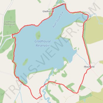
Gladhouse reservoir loop
- Distance: 4.8 mi
- Elevation gain: 213 ft
- Maximum elevation: 1,007 ft
- Elevation loss: 213 ft
- Minimum elevation: 889 ft
- Moving time: 1 h 33 m
- Moving speed: 3.1 mph
- Maximum speed: 10.6 mph
- Total time: 1 h 43 m
- Global speed: 2.8 mph
Interactive trail map
Trail profile
- Distance: 4.8 mi
- Elevation gain: 213 ft
- Maximum elevation: 1,007 ft
- Elevation loss: 213 ft
- Minimum elevation: 889 ft
- Moving time: 1 h 33 m
- Moving speed: 3.1 mph
- Maximum speed: 10.6 mph
- Total time: 1 h 43 m
- Global speed: 2.8 mph
About this trail
Name: Gladhouse reservoir loop trail, distance, elevation, map, profile, GPS track
Start: Gladhouse, Midlothian, Scotland, EH23 4TA, United Kingdom (55.77250 -3.13145)
End: Gladhouse, Midlothian, Scotland, EH23 4TA, United Kingdom (55.77266 -3.13131)
Coordinates: 55.75900 -3.13167 55.77904 -3.10215
Other hiking, mountain biking, running and outdoor activity trails
Click on a trail to view its statistics, map and profile.
Cycleroute Edinburgh
United Kingdom > Scotland > City of Edinburgh
Summer!
Distance: 47.5 mi • Elevation gain: 2,907 ft • Maximum elevation: 1,066 ft