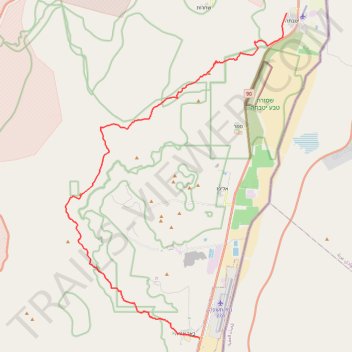
Marathon Timna Circle
מרתון סובב תמנע: סובב מוניומנטי של בקעת תמנע מיוטבתה לבאר אורה
- Distance: 26.4 mi
- Elevation gain: 4,459 ft
- Maximum elevation: 2,746 ft
- Elevation loss: 4,472 ft
- Minimum elevation: 223 ft
- Moving time: 12 h 26 m
- Moving speed: 2.1 mph
- Maximum speed: 2.6 mph
- Total time: 12 h 26 m
- Global speed: 2.1 mph
Interactive trail map
Trail profile
- Distance: 26.4 mi
- Elevation gain: 4,459 ft
- Maximum elevation: 2,746 ft
- Elevation loss: 4,472 ft
- Minimum elevation: 223 ft
- Moving time: 12 h 26 m
- Moving speed: 2.1 mph
- Maximum speed: 2.6 mph
- Total time: 12 h 26 m
- Global speed: 2.1 mph
About this trail
Name: Marathon Timna Circle trail, distance, elevation, map, profile, GPS track
End: 1095, Eilat, Beersheba Subdistrict, South District, 8881000, Israel (29.70695 34.99679)
Coordinates: 29.70695 34.90493 29.90030 35.05630
Other hiking, mountain biking, running and outdoor activity trails
Click on a trail to view its statistics, map and profile.
Mount Yotveta and Mount Argaman
Israel > South District > Hevel Eilot Regional Council > Yotvata
הר יוטבתה והר ארגמן: מעלה צאלה וחיבור על שביל ישראל
Distance: 18.8 mi • Elevation gain: 3,074 ft • Maximum elevation: 2,365 ft
Mount Yehoram to Beer Ora
Israel > South District > Hevel Eilot Regional Council
הר יהורם לבאר אורה: קו ארוך וטכני בין הרי אילת
Distance: 17.7 mi • Elevation gain: 3,202 ft • Maximum elevation: 2,218 ft
Timna Park Sightseeing
Israel > South District > Hevel Eilot Regional Council
סובב תמנע קטן: ביקור באטרקציות פארק תמנע
Distance: 15.8 mi • Elevation gain: 2,192 ft • Maximum elevation: 1,440 ft
Yotveta - Shaharut
Israel > South District > Hevel Eilot Regional Council > Yotvata
יטבתה לשחרות: מעלה זוגן וביקור בישוב הכי קול בערבה
Distance: 13.6 mi • Elevation gain: 2,526 ft • Maximum elevation: 1,959 ft
Timna Park Circle
Israel > South District > Hevel Eilot Regional Council
סובב תמנע גדול: מעלה מלחן, הר ברך והר תמנע
Distance: 18.3 mi • Elevation gain: 3,845 ft • Maximum elevation: 2,746 ft