Thank you for supporting this site ❤️
Make a donation
Make a donation
Gear up for your next adventure:
As an Amazon Associate, this site earns from qualifying purchases at no extra cost to you.
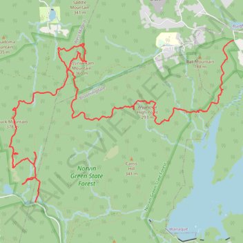
Norvin Green State Forest Hike
- Distance: 9.2 mi
- Elevation gain: 1,289 ft
- Maximum elevation: 1,211 ft
- Elevation loss: 1,762 ft
- Minimum elevation: 374 ft
- Moving time: 4 h 30 m
- Moving speed: 2.0 mph
- Maximum speed: 6.8 mph
- Total time: 6 h 26 m
- Global speed: 1.4 mph
Interactive trail map
Thank you for supporting this site ❤️
Make a donation
Make a donation
Gear up for your next adventure:
As an Amazon Associate, this site earns from qualifying purchases at no extra cost to you.
Trail profile
- Distance: 9.2 mi
- Elevation gain: 1,289 ft
- Maximum elevation: 1,211 ft
- Elevation loss: 1,762 ft
- Minimum elevation: 374 ft
- Moving time: 4 h 30 m
- Moving speed: 2.0 mph
- Maximum speed: 6.8 mph
- Total time: 6 h 26 m
- Global speed: 1.4 mph
Thank you for supporting this site ❤️
Make a donation
Make a donation
Gear up for your next adventure:
As an Amazon Associate, this site earns from qualifying purchases at no extra cost to you.
About this trail
Name: Norvin Green State Forest Hike trail, distance, elevation, map, profile, GPS track
Coordinates: 41.04583 -74.35552 41.07050 -74.31022
Topography: Passaic County topographic map, elevation, terrain
Thank you for supporting this site ❤️
Make a donation
Make a donation
Gear up for your next adventure:
As an Amazon Associate, this site earns from qualifying purchases at no extra cost to you.