Thank you for supporting this site ❤️
Make a donation
Make a donation
Gear up for your next adventure:
As an Amazon Associate, this site earns from qualifying purchases at no extra cost to you.
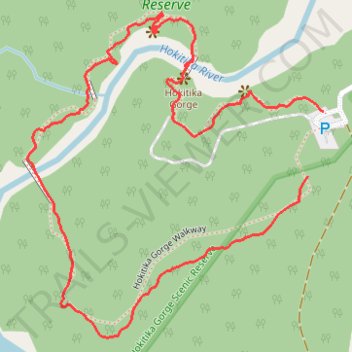
Hokitika Gorge Walkway
- Distance: 1.3 mi
- Elevation gain: 207 ft
- Maximum elevation: 377 ft
- Elevation loss: 174 ft
- Minimum elevation: 272 ft
- Moving time: 35 m 17 s
- Moving speed: 2.3 mph
- Maximum speed: 5.1 mph
- Total time: 44 m 24 s
- Global speed: 1.8 mph
Interactive trail map
Thank you for supporting this site ❤️
Make a donation
Make a donation
Gear up for your next adventure:
As an Amazon Associate, this site earns from qualifying purchases at no extra cost to you.
Trail profile
- Distance: 1.3 mi
- Elevation gain: 207 ft
- Maximum elevation: 377 ft
- Elevation loss: 174 ft
- Minimum elevation: 272 ft
- Moving time: 35 m 17 s
- Moving speed: 2.3 mph
- Maximum speed: 5.1 mph
- Total time: 44 m 24 s
- Global speed: 1.8 mph
Thank you for supporting this site ❤️
Make a donation
Make a donation
Gear up for your next adventure:
As an Amazon Associate, this site earns from qualifying purchases at no extra cost to you.
About this trail
Name: Hokitika Gorge Walkway trail, distance, elevation, map, profile, GPS track
Start: Hokitika Gorge Walk, Westland District, West Coast, New Zealand (-42.95632 171.01967)
End: Hokitika Gorge Walkway, Westland District, West Coast, New Zealand (-42.95737 171.01932)
Coordinates: -42.95998 171.01314 -42.95473 171.01967
Thank you for supporting this site ❤️
Make a donation
Make a donation
Gear up for your next adventure:
As an Amazon Associate, this site earns from qualifying purchases at no extra cost to you.
Other hiking, mountain biking, running and outdoor activity trails
Click on a trail to view its statistics, map and profile.