Make a donation
Gear up for your next adventure:
As an Amazon Associate, this site earns from qualifying purchases at no extra cost to you.
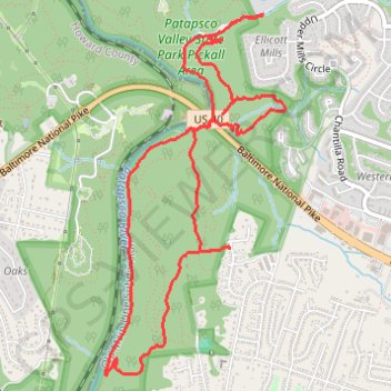
Patapsco Valley State Park Loop
Lopp hike through the Patapsco Valley State Park Rockhaven Area and Pickall Area via Rockhaven Avenue, Rockhaven Trail, Mill Race Trail, Patapsco River, Patapsco Thru Trail, Devil's Horns and Shale. #Hiking #Loop #Park #Forest #Nature #River
- Distance: 5.6 mi
- Elevation gain: 741 ft
- Maximum elevation: 463 ft
- Elevation loss: 745 ft
- Minimum elevation: 171 ft
- Moving time: 2 h 36 m
- Moving speed: 2.2 mph
- Maximum speed: 13.6 mph
- Total time: 2 h 51 m
- Global speed: 2.0 mph
Interactive trail map
Make a donation
Gear up for your next adventure:
As an Amazon Associate, this site earns from qualifying purchases at no extra cost to you.
Trail profile
- Distance: 5.6 mi
- Elevation gain: 741 ft
- Maximum elevation: 463 ft
- Elevation loss: 745 ft
- Minimum elevation: 171 ft
- Moving time: 2 h 36 m
- Moving speed: 2.2 mph
- Maximum speed: 13.6 mph
- Total time: 2 h 51 m
- Global speed: 2.0 mph
Make a donation
Gear up for your next adventure:
As an Amazon Associate, this site earns from qualifying purchases at no extra cost to you.
About this trail
Name: Patapsco Valley State Park Loop trail, distance, elevation, map, profile, GPS track
Coordinates: 39.27936 -76.78656 39.30128 -76.77244
Topography: Baltimore County topographic map, elevation, terrain
Make a donation
Gear up for your next adventure:
As an Amazon Associate, this site earns from qualifying purchases at no extra cost to you.