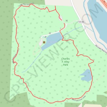
Alley Park Loop
Loop hike through Charles F. Alley Park around Lake Loretta via Alley Park Outer Loop. #Hiking #Loop #Park #Nature #Forest #Lake
- Distance: 2.3 mi
- Elevation gain: 394 ft
- Maximum elevation: 1,070 ft
- Elevation loss: 394 ft
- Minimum elevation: 840 ft
- Moving time: 1 h 4 m
- Moving speed: 2.2 mph
- Maximum speed: 4.5 mph
- Total time: 1 h 11 m
- Global speed: 2.0 mph
Interactive trail map
Trail profile
- Distance: 2.3 mi
- Elevation gain: 394 ft
- Maximum elevation: 1,070 ft
- Elevation loss: 394 ft
- Minimum elevation: 840 ft
- Moving time: 1 h 4 m
- Moving speed: 2.2 mph
- Maximum speed: 4.5 mph
- Total time: 1 h 11 m
- Global speed: 2.0 mph
About this trail
Name: Alley Park Loop trail, distance, elevation, map, profile, GPS track
Coordinates: 39.67408 -82.58310 39.68377 -82.57288
Topography: Lancaster topographic map, elevation, terrain
Other hiking, mountain biking, running and outdoor activity trails
Click on a trail to view its statistics, map and profile.
Alley Park trails
United States > Ohio > Fairfield County > Lancaster > Whites
Distance: 2.0 mi • Elevation gain: 358 ft • Maximum elevation: 994 ft