Make a donation
Gear up for your next adventure:
As an Amazon Associate, this site earns from qualifying purchases at no extra cost to you.
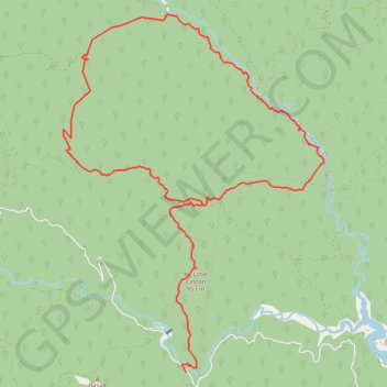
Upper Thomson Loop
Interactive trail map
Make a donation
Gear up for your next adventure:
As an Amazon Associate, this site earns from qualifying purchases at no extra cost to you.
Trail profile
- Distance: 20.2 mi
- Elevation gain: 5,233 ft
- Maximum elevation: 3,652 ft
- Elevation loss: 5,223 ft
- Minimum elevation: 1,568 ft
Make a donation
Gear up for your next adventure:
As an Amazon Associate, this site earns from qualifying purchases at no extra cost to you.
About this trail
Name: Upper Thomson Loop trail, distance, elevation, map, profile, GPS track
Start: Thomson - Jordan Road, Jericho, Shire of Baw Baw, Victoria, Australia (-37.71438 146.27523)
End: Thomson - Jordan Road, Jericho, Shire of Baw Baw, Victoria, Australia (-37.71530 146.27604)
Coordinates: -37.71530 146.24214 -37.63734 146.31374
Make a donation
Gear up for your next adventure:
As an Amazon Associate, this site earns from qualifying purchases at no extra cost to you.
Other hiking, mountain biking, running and outdoor activity trails
Click on a trail to view its statistics, map and profile.
Traralgon - Walhalla - Woods Point
Australia > Victoria > Traralgon
#Bike
Distance: 77.4 mi • Elevation gain: 13,970 ft • Maximum elevation: 3,822 ft
Moe - Woods Point
#Bike
Distance: 67.8 mi • Elevation gain: 10,810 ft • Maximum elevation: 3,822 ft