Make a donation
Gear up for your next adventure:
As an Amazon Associate, this site earns from qualifying purchases at no extra cost to you.
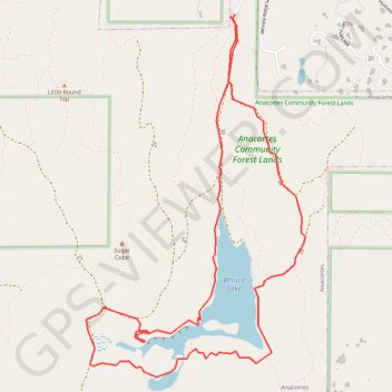
Whistle Lake Loop
Loop hike around Whistle Lake via Gerry Wallrath Trail, Toot Swamp and Kenny Oaks Trail in the Anacortes Community Forest Lands on the Fidalgo Island. #Hiking #Loop #Lake #Forest #Nature
- Distance: 4.1 mi
- Elevation gain: 561 ft
- Maximum elevation: 594 ft
- Elevation loss: 564 ft
- Minimum elevation: 413 ft
- Moving time: 1 h 50 m
- Moving speed: 2.2 mph
- Maximum speed: 5.7 mph
- Total time: 2 h 16 m
- Global speed: 1.8 mph
Interactive trail map
Make a donation
Gear up for your next adventure:
As an Amazon Associate, this site earns from qualifying purchases at no extra cost to you.
Trail profile
- Distance: 4.1 mi
- Elevation gain: 561 ft
- Maximum elevation: 594 ft
- Elevation loss: 564 ft
- Minimum elevation: 413 ft
- Moving time: 1 h 50 m
- Moving speed: 2.2 mph
- Maximum speed: 5.7 mph
- Total time: 2 h 16 m
- Global speed: 1.8 mph
Make a donation
Gear up for your next adventure:
As an Amazon Associate, this site earns from qualifying purchases at no extra cost to you.
About this trail
Name: Whistle Lake Loop trail, distance, elevation, map, profile, GPS track
Start: 20, Anacortes, Skagit County, Washington, 98221, United States (48.47347 -122.60537)
End: 20, Anacortes, Skagit County, Washington, 98221, United States (48.47362 -122.60528)
Coordinates: 48.45614 -122.61599 48.47367 -122.60005
Topography: Skagit County topographic map, elevation, terrain
Make a donation
Gear up for your next adventure:
As an Amazon Associate, this site earns from qualifying purchases at no extra cost to you.