Thank you for supporting this site ❤️
Make a donation
Make a donation
Gear up for your next adventure:
As an Amazon Associate, this site earns from qualifying purchases at no extra cost to you.
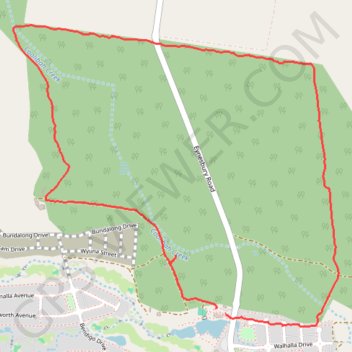
Eynesbury Trail
Eynesbury walk
- Distance: 3.7 mi
- Elevation gain: 108 ft
- Maximum elevation: 335 ft
- Elevation loss: 108 ft
- Minimum elevation: 276 ft
- Moving time: 1 h 36 m
- Moving speed: 2.3 mph
- Maximum speed: 3.3 mph
- Total time: 1 h 40 m
- Global speed: 2.2 mph
Interactive trail map
Thank you for supporting this site ❤️
Make a donation
Make a donation
Gear up for your next adventure:
As an Amazon Associate, this site earns from qualifying purchases at no extra cost to you.
Trail profile
- Distance: 3.7 mi
- Elevation gain: 108 ft
- Maximum elevation: 335 ft
- Elevation loss: 108 ft
- Minimum elevation: 276 ft
- Moving time: 1 h 36 m
- Moving speed: 2.3 mph
- Maximum speed: 3.3 mph
- Total time: 1 h 40 m
- Global speed: 2.2 mph
Thank you for supporting this site ❤️
Make a donation
Make a donation
Gear up for your next adventure:
As an Amazon Associate, this site earns from qualifying purchases at no extra cost to you.
About this trail
Name: Eynesbury Trail trail, distance, elevation, map, profile, GPS track
Coordinates: -37.78924 144.55418 -37.77505 144.57354
Thank you for supporting this site ❤️
Make a donation
Make a donation
Gear up for your next adventure:
As an Amazon Associate, this site earns from qualifying purchases at no extra cost to you.