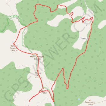
Vardenik: od fabrike 'Rosa', vrhovi Veliki Strešer, Mali Str...
- Distance: 9.8 mi
- Elevation gain: 2,953 ft
- Maximum elevation: 6,132 ft
- Elevation loss: 2,959 ft
- Minimum elevation: 3,563 ft
- Moving time: 4 h 47 m
- Moving speed: 2.1 mph
- Maximum speed: 5.3 mph
- Total time: 6 h 55 m
- Global speed: 1.4 mph
Interactive trail map
Trail profile
- Distance: 9.8 mi
- Elevation gain: 2,953 ft
- Maximum elevation: 6,132 ft
- Elevation loss: 2,959 ft
- Minimum elevation: 3,563 ft
- Moving time: 4 h 47 m
- Moving speed: 2.1 mph
- Maximum speed: 5.3 mph
- Total time: 6 h 55 m
- Global speed: 1.4 mph
About this trail
Name: Vardenik: od fabrike 'Rosa', vrhovi Veliki Strešer, Mali Str... trail, distance, elevation, map, profile, GPS track
Coordinates: 42.60753 22.26701 42.63961 22.30267
Other hiking, mountain biking, running and outdoor activity trails
Click on a trail to view its statistics, map and profile.
Besna Kobila (1923m)-Veliki Streser (1878m)-Topli Do hiking,...
Serbia > Central Serbia > Pcinja Administrative District > Vranjska Banja > Kriva Feja > Barje
Distance: 16.9 mi • Elevation gain: 3,501 ft • Maximum elevation: 6,257 ft
Fabrika Rosa - Veliki Streser 1876m -Mali Streser 1757m - Pa...
Serbia > Central Serbia > Pcinja Administrative District > Surdulica Municipality > Vlasina Okruglica > Topli Do
Distance: 10.6 mi • Elevation gain: 3,091 ft • Maximum elevation: 6,132 ft