Make a donation
Gear up for your next adventure:
As an Amazon Associate, this site earns from qualifying purchases at no extra cost to you.
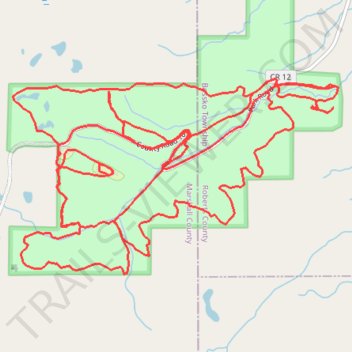
Sica Hollow State Park Loop
- Distance: 15.1 mi
- Elevation gain: 1,791 ft
- Maximum elevation: 1,995 ft
- Elevation loss: 1,791 ft
- Minimum elevation: 1,545 ft
- Moving time: 2 h 20 m
- Moving speed: 6.5 mph
- Maximum speed: 12.5 mph
- Total time: 2 h 32 m
- Global speed: 5.9 mph
Interactive trail map
Make a donation
Gear up for your next adventure:
As an Amazon Associate, this site earns from qualifying purchases at no extra cost to you.
Trail profile
- Distance: 15.1 mi
- Elevation gain: 1,791 ft
- Maximum elevation: 1,995 ft
- Elevation loss: 1,791 ft
- Minimum elevation: 1,545 ft
- Moving time: 2 h 20 m
- Moving speed: 6.5 mph
- Maximum speed: 12.5 mph
- Total time: 2 h 32 m
- Global speed: 5.9 mph
Make a donation
Gear up for your next adventure:
As an Amazon Associate, this site earns from qualifying purchases at no extra cost to you.
About this trail
Name: Sica Hollow State Park Loop trail, distance, elevation, map, profile, GPS track
Start: 113th Street, Bossko Township, Roberts County, South Dakota, United States (45.74653 -97.21260)
End: 113th Street, Bossko Township, Roberts County, South Dakota, United States (45.74648 -97.21271)
Coordinates: 45.73230 -97.24746 45.74711 -97.21210
Topography: Roberts County topographic map, elevation, terrain
Make a donation
Gear up for your next adventure:
As an Amazon Associate, this site earns from qualifying purchases at no extra cost to you.