Thank you for supporting this site ❤️
Make a donation
Make a donation
Gear up for your next adventure:
As an Amazon Associate, this site earns from qualifying purchases at no extra cost to you.
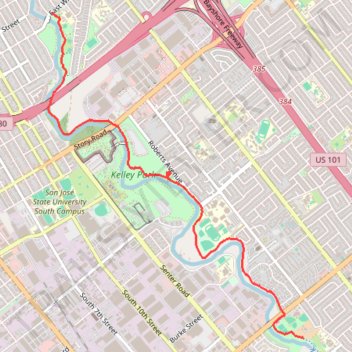
Coyote Creek Trail between Tully Road and William Street
- Distance: 3.6 mi
- Elevation gain: 89 ft
- Maximum elevation: 157 ft
- Elevation loss: 128 ft
- Minimum elevation: 82 ft
- Moving time: 19 m 27 s
- Moving speed: 11.2 mph
- Maximum speed: 20.1 mph
- Total time: 21 m 37 s
- Global speed: 10.1 mph
Interactive trail map
Thank you for supporting this site ❤️
Make a donation
Make a donation
Gear up for your next adventure:
As an Amazon Associate, this site earns from qualifying purchases at no extra cost to you.
Trail profile
- Distance: 3.6 mi
- Elevation gain: 89 ft
- Maximum elevation: 157 ft
- Elevation loss: 128 ft
- Minimum elevation: 82 ft
- Moving time: 19 m 27 s
- Moving speed: 11.2 mph
- Maximum speed: 20.1 mph
- Total time: 21 m 37 s
- Global speed: 10.1 mph
Thank you for supporting this site ❤️
Make a donation
Make a donation
Gear up for your next adventure:
As an Amazon Associate, this site earns from qualifying purchases at no extra cost to you.
About this trail
Name: Coyote Creek Trail between Tully Road and William Street trail, distance, elevation, map, profile, GPS track
Coordinates: 37.30918 -121.86821 37.33756 -121.84021
Topography: San Jose topographic map, elevation, terrain
Thank you for supporting this site ❤️
Make a donation
Make a donation
Gear up for your next adventure:
As an Amazon Associate, this site earns from qualifying purchases at no extra cost to you.