Thank you for supporting this site ❤️
Make a donation
Make a donation
Gear up for your next adventure:
As an Amazon Associate, this site earns from qualifying purchases at no extra cost to you.
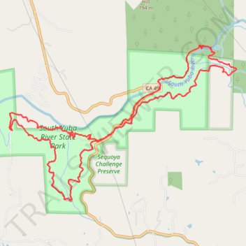
Independence Trail / South Yuba River
- Distance: 8.2 mi
- Elevation gain: 2,264 ft
- Maximum elevation: 1,535 ft
- Elevation loss: 2,326 ft
- Minimum elevation: 1,066 ft
- Moving time: 3 h 36 m
- Moving speed: 2.3 mph
- Maximum speed: 5.5 mph
- Total time: 5 h 12 m
- Global speed: 1.6 mph
Interactive trail map
Thank you for supporting this site ❤️
Make a donation
Make a donation
Gear up for your next adventure:
As an Amazon Associate, this site earns from qualifying purchases at no extra cost to you.
Trail profile
- Distance: 8.2 mi
- Elevation gain: 2,264 ft
- Maximum elevation: 1,535 ft
- Elevation loss: 2,326 ft
- Minimum elevation: 1,066 ft
- Moving time: 3 h 36 m
- Moving speed: 2.3 mph
- Maximum speed: 5.5 mph
- Total time: 5 h 12 m
- Global speed: 1.6 mph
Thank you for supporting this site ❤️
Make a donation
Make a donation
Gear up for your next adventure:
As an Amazon Associate, this site earns from qualifying purchases at no extra cost to you.
About this trail
Name: Independence Trail / South Yuba River trail, distance, elevation, map, profile, GPS track
Start: Independence Trail, Nevada County, California, United States (39.29157 -121.09718)
End: CA 49, Nevada County, California, United States (39.29265 -121.09603)
Coordinates: 39.28263 -121.11498 39.30315 -121.07608
Topography: Nevada County topographic map, elevation, terrain
Thank you for supporting this site ❤️
Make a donation
Make a donation
Gear up for your next adventure:
As an Amazon Associate, this site earns from qualifying purchases at no extra cost to you.