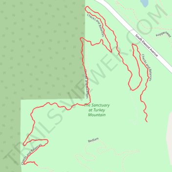
Turkey Mountain Checks and Balances MTB Trail
- Distance: 1.4 mi
- Elevation gain: 112 ft
- Maximum elevation: 860 ft
- Elevation loss: 56 ft
- Minimum elevation: 797 ft
- Moving time: 27 m 17 s
- Moving speed: 3.0 mph
- Maximum speed: 5.5 mph
- Total time: 27 m 17 s
- Global speed: 3.0 mph
Interactive trail map
Trail profile
- Distance: 1.4 mi
- Elevation gain: 112 ft
- Maximum elevation: 860 ft
- Elevation loss: 56 ft
- Minimum elevation: 797 ft
- Moving time: 27 m 17 s
- Moving speed: 3.0 mph
- Maximum speed: 5.5 mph
- Total time: 27 m 17 s
- Global speed: 3.0 mph
About this trail
Name: Turkey Mountain Checks and Balances MTB Trail trail, distance, elevation, map, profile, GPS track
Start: Checks and Balances, Tulsa, Tulsa County, Oklahoma, 74132, United States (36.06964 -96.00217)
End: Checks and Balances, Tulsa, Tulsa County, Oklahoma, 74132, United States (36.07103 -95.99784)
Coordinates: 36.06964 -96.00275 36.07472 -95.99777
Topography: Tulsa topographic map, elevation, terrain
Other hiking, mountain biking, running and outdoor activity trails
Click on a trail to view its statistics, map and profile.
Turkey Mountain Ten Four MTB Trail
United States > Oklahoma > Tulsa County > Tulsa
Distance: 0.5 mi • Elevation gain: 7 ft • Maximum elevation: 856 ft