Thank you for supporting this site ❤️
Make a donation
Make a donation
Gear up for your next adventure:
As an Amazon Associate, this site earns from qualifying purchases at no extra cost to you.
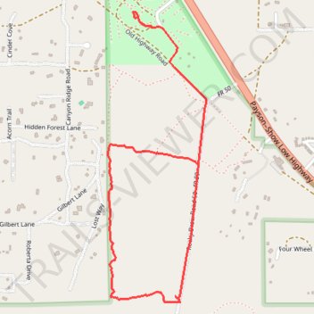
Hiking trails in Tall Timbers
- Distance: 2.2 mi
- Elevation gain: 118 ft
- Maximum elevation: 6,719 ft
- Elevation loss: 98 ft
- Minimum elevation: 6,617 ft
- Moving time: 45 m 17 s
- Moving speed: 3.0 mph
- Maximum speed: 19.9 mph
- Total time: 48 m 24 s
- Global speed: 2.8 mph
Interactive trail map
Thank you for supporting this site ❤️
Make a donation
Make a donation
Gear up for your next adventure:
As an Amazon Associate, this site earns from qualifying purchases at no extra cost to you.
Trail profile
- Distance: 2.2 mi
- Elevation gain: 118 ft
- Maximum elevation: 6,719 ft
- Elevation loss: 98 ft
- Minimum elevation: 6,617 ft
- Moving time: 45 m 17 s
- Moving speed: 3.0 mph
- Maximum speed: 19.9 mph
- Total time: 48 m 24 s
- Global speed: 2.8 mph
Thank you for supporting this site ❤️
Make a donation
Make a donation
Gear up for your next adventure:
As an Amazon Associate, this site earns from qualifying purchases at no extra cost to you.
About this trail
Name: Hiking trails in Tall Timbers trail, distance, elevation, map, profile, GPS track
Start: 18, Navajo County, Arizona, 85933, United States (34.39935 -110.56450)
End: Rocky Draw Road 50, Navajo County, Arizona, 85933, United States (34.39304 -110.56168)
Coordinates: 34.38669 -110.56666 34.40000 -110.56120
Topography: Navajo County topographic map, elevation, terrain
Thank you for supporting this site ❤️
Make a donation
Make a donation
Gear up for your next adventure:
As an Amazon Associate, this site earns from qualifying purchases at no extra cost to you.