
Patriot's Park Loop
Starting at Patriot’s Park in Grovetown, this loop begins among recreation fields, ponds, and wooded park edges before joining the Bartram Bike and Walk Trail for a first circuit around the Bartram Trail neighborhood, its residential green spaces, and the golf-course landscape.
It then connects with the Euchee Creek Greenway, a walking, running, and cycling corridor tied to Patriots Park and the Bartram Trails network, where the route shifts into a more natural greenway setting.
The return follows shaded woodland, creekside lowlands, boardwalk-like passages, and quiet suburban paths near Chastain Place before curving back toward Columbia Road and Patriot’s Park, creating a varied park, neighborhood, golf-course, and forest loop.
#Hiking #Running #Loop #Park #Nature #Forest
- Distance: 13.1 mi
- Elevation gain: 735 ft
- Maximum elevation: 420 ft
- Elevation loss: 738 ft
- Minimum elevation: 240 ft
- Moving time: 2 h 26 m
- Moving speed: 5.4 mph
- Maximum speed: 18.4 mph
- Total time: 3 h 40 m
- Global speed: 3.6 mph
Interactive trail map
Trail profile
- Distance: 13.1 mi
- Elevation gain: 735 ft
- Maximum elevation: 420 ft
- Elevation loss: 738 ft
- Minimum elevation: 240 ft
- Moving time: 2 h 26 m
- Moving speed: 5.4 mph
- Maximum speed: 18.4 mph
- Total time: 3 h 40 m
- Global speed: 3.6 mph
About this trail
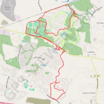
Name: Patriot's Park Loop trail, distance, elevation, map, profile, GPS track
Coordinates: 33.48993 -82.23516 33.53033 -82.20837
Topography: Columbia County topographic map, elevation, terrain