Make a donation
Gear up for your next adventure:
As an Amazon Associate, this site earns from qualifying purchases at no extra cost to you.
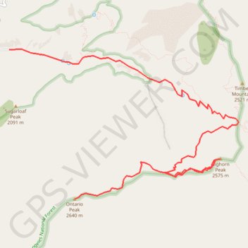
Ontario Peak and Bighorn Peak
Interactive trail map
Make a donation
Gear up for your next adventure:
As an Amazon Associate, this site earns from qualifying purchases at no extra cost to you.
Trail profile
- Distance: 6.9 mi
- Elevation gain: 4,373 ft
- Maximum elevation: 8,665 ft
- Elevation loss: 751 ft
- Minimum elevation: 5,039 ft
Make a donation
Gear up for your next adventure:
As an Amazon Associate, this site earns from qualifying purchases at no extra cost to you.
About this trail
Name: Ontario Peak and Bighorn Peak trail, distance, elevation, map, profile, GPS track
Start: Icehouse Canyon Trail, San Bernardino County, California, 91759, United States (34.25002 -117.63589)
Coordinates: 34.22770 -117.63589 34.25012 -117.59435
Topography: San Bernardino County topographic map, elevation, terrain
Make a donation
Gear up for your next adventure:
As an Amazon Associate, this site earns from qualifying purchases at no extra cost to you.
Other hiking, mountain biking, running and outdoor activity trails
Click on a trail to view its statistics, map and profile.
Icehouse Saddle via Icehouse Canyon
United States > California > San Bernardino County
Starting from the Icehouse Canyon Trailhead near Mount Baldy Road, the route climbs into the shaded lower canyon, following Icehouse Creek past wooded slopes and remnants of old recreation cabins in the Angeles National Forest. The trail continues east through Icehouse Canyon into the Cucamonga Wilderness,…
Distance: 7.8 mi • Elevation gain: 2,759 ft • Maximum elevation: 7,615 ft
Cucamonga Peak Trail via Icehouse Canyon Trail in Cucamonga Wilderness
United States > California > San Bernardino County
The Cucamonga Peak Trail via Icehouse Canyon offers hikers a rewarding journey through diverse landscapes, culminating in panoramic vistas from the summit. The trail begins in a lush, shaded canyon, following the serene Icehouse Creek and passing remnants of historic stone cabins. As you ascend, the terrain…
Distance: 11.7 mi • Elevation gain: 4,370 ft • Maximum elevation: 8,839 ft
Three T's Trail
United States > California > San Bernardino County
Loop hike to Timber Mountain, Telegraph Peak and Thunder Mountain along the Three T's Trail via Icehouse Canyon Trail, Icehouse Saddle, Mount Baldy Notch and ount Baldy Road in Angeles National Forest. #Hiking #Loop #Mountain #Nature #Forest #Angeles
Distance: 15.1 mi • Elevation gain: 5,476 ft • Maximum elevation: 8,944 ft
Make a donation
Gear up for your next adventure:
As an Amazon Associate, this site earns from qualifying purchases at no extra cost to you.