Thank you for supporting this site ❤️
Make a donation
Make a donation
Gear up for your next adventure:
As an Amazon Associate, this site earns from qualifying purchases at no extra cost to you.
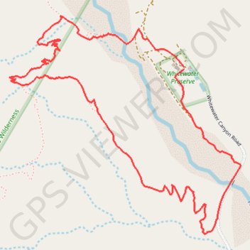
Whitewater Canyon Loop
Loop hike around the Whitewater River via the Pacific Crest Trail (PCT) and the Whitewater Canyon Road in the Sand to Snow National Monument. #Hiking #Loop #Canyon #River #Mountain #Nature #PCT
- Distance: 3.7 mi
- Elevation gain: 817 ft
- Maximum elevation: 2,762 ft
- Elevation loss: 820 ft
- Minimum elevation: 2,087 ft
Interactive trail map
Thank you for supporting this site ❤️
Make a donation
Make a donation
Gear up for your next adventure:
As an Amazon Associate, this site earns from qualifying purchases at no extra cost to you.
Trail profile
- Distance: 3.7 mi
- Elevation gain: 817 ft
- Maximum elevation: 2,762 ft
- Elevation loss: 820 ft
- Minimum elevation: 2,087 ft
Thank you for supporting this site ❤️
Make a donation
Make a donation
Gear up for your next adventure:
As an Amazon Associate, this site earns from qualifying purchases at no extra cost to you.
About this trail
Name: Whitewater Canyon Loop trail, distance, elevation, map, profile, GPS track
Coordinates: 33.97987 -116.66780 33.99196 -116.65236
Topography: Riverside County topographic map, elevation, terrain
Thank you for supporting this site ❤️
Make a donation
Make a donation
Gear up for your next adventure:
As an Amazon Associate, this site earns from qualifying purchases at no extra cost to you.