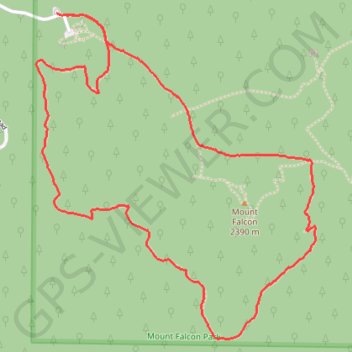
Mount Falcon Loop via Parmalee Trail, Meadow Trail and Castle Trail
The Mount Falcon Loop via Parmalee, Meadow, and Castle Trails offers a diverse hiking experience through woodland, grassland, and rocky landscapes. As you make your way along the route, you’ll encounter expansive views of the Denver skyline, the Front Range peaks, and the distant Mount Evans Wilderness. Hikers are treated to a mix of natural beauty, including towering pine forests and open meadows, making it a pleasant and varied experience. #Hiking #Loop #Forest #Nature #Overlook
- Distance: 3.3 mi
- Elevation gain: 620 ft
- Maximum elevation: 7,743 ft
- Elevation loss: 627 ft
- Minimum elevation: 7,244 ft
- Moving time: 1 h 14 m
- Moving speed: 2.7 mph
- Maximum speed: 3.8 mph
- Total time: 1 h 18 m
- Global speed: 2.5 mph
Interactive trail map
Trail profile
About this trail
Name: Mount Falcon Loop via Parmalee Trail, Meadow Trail and Castle Trail trail, distance, elevation, map, profile, GPS track
Start: Mount Falcon Road, Jefferson County, Colorado, 80454, United States (39.63687 -105.24009)
End: Parmalee Trail, Jefferson County, Colorado, 80454, United States (39.63679 -105.23967)
Coordinates: 39.62406 -105.24116 39.63687 -105.22687
Topography: Jefferson County topographic map, elevation, terrain
Other hiking, mountain biking, running and outdoor activity trails
Click on a trail to view its statistics, map and profile.