Riding solstice while I can. Salida, co
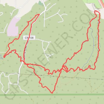
- Distance: 9.1 mi
- Elevation gain: 1,437 ft
- Maximum elevation: 7,927 ft
- Elevation loss: 1,434 ft
- Minimum elevation: 7,067 ft
- Moving time: 1 h 11 m
- Moving speed: 7.6 mph
- Maximum speed: 24.1 mph
- Total time: 1 h 27 m
- Global speed: 6.3 mph
Interactive trail map
Trail profile
- Distance: 9.1 mi
- Elevation gain: 1,437 ft
- Maximum elevation: 7,927 ft
- Elevation loss: 1,434 ft
- Minimum elevation: 7,067 ft
- Moving time: 1 h 11 m
- Moving speed: 7.6 mph
- Maximum speed: 24.1 mph
- Total time: 1 h 27 m
- Global speed: 6.3 mph
About this trail
Name: Riding solstice while I can. Salida, co trail, distance, elevation, map, profile, GPS track
Start: BLM 5672, Salida, Chaffee County, Colorado, United States (38.51066 -105.97987)
End: BLM 5672, Salida, Chaffee County, Colorado, United States (38.51058 -105.97974)
Coordinates: 38.49233 -106.01008 38.51295 -105.97940
Topography: Chaffee County topographic map, elevation, terrain