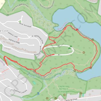
Sugarloaf Bay - Harold Reid Foreshore Track
Harold Reid Reserve. #Hiking #Loop #HaroldReid
- Distance: 2.3 mi
- Elevation gain: 469 ft
- Maximum elevation: 243 ft
- Elevation loss: 476 ft
- Minimum elevation: 3 ft
- Moving time: 1 h 2 m
- Moving speed: 2.2 mph
- Maximum speed: 4.4 mph
- Total time: 1 h 11 m
- Global speed: 1.9 mph
Interactive trail map
Trail profile
- Distance: 2.3 mi
- Elevation gain: 469 ft
- Maximum elevation: 243 ft
- Elevation loss: 476 ft
- Minimum elevation: 3 ft
- Moving time: 1 h 2 m
- Moving speed: 2.2 mph
- Maximum speed: 4.4 mph
- Total time: 1 h 11 m
- Global speed: 1.9 mph
About this trail
Name: Sugarloaf Bay - Harold Reid Foreshore Track trail, distance, elevation, map, profile, GPS track
Coordinates: -33.79716 151.21164 -33.79230 151.22254