Make a donation
Gear up for your next adventure:
As an Amazon Associate, this site earns from qualifying purchases at no extra cost to you.
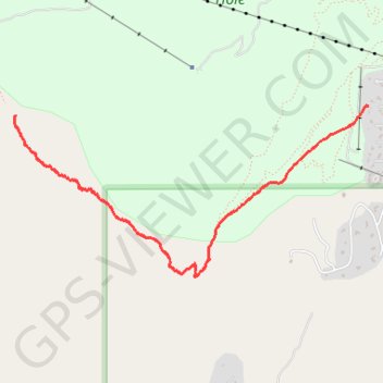
Rock Springs Buttress Approach Trail
Teton County Hiking
- Distance: 2.5 mi
- Elevation gain: 2,228 ft
- Maximum elevation: 8,802 ft
- Elevation loss: 3 ft
- Minimum elevation: 6,575 ft
Interactive trail map
Make a donation
Gear up for your next adventure:
As an Amazon Associate, this site earns from qualifying purchases at no extra cost to you.
Trail profile
- Distance: 2.5 mi
- Elevation gain: 2,228 ft
- Maximum elevation: 8,802 ft
- Elevation loss: 3 ft
- Minimum elevation: 6,575 ft
Make a donation
Gear up for your next adventure:
As an Amazon Associate, this site earns from qualifying purchases at no extra cost to you.
About this trail
Name: Rock Springs Buttress Approach Trail trail, distance, elevation, map, profile, GPS track
Start: Teton Village, Teton County, Wyoming, 83025, United States (43.58684 -110.83951)
End: Rock Spring Loop, Teton Village, Teton County, Wyoming, 83025, United States (43.58624 -110.86967)
Coordinates: 43.57622 -110.86978 43.58684 -110.83951
Topography: Teton County topographic map, elevation, terrain
Make a donation
Gear up for your next adventure:
As an Amazon Associate, this site earns from qualifying purchases at no extra cost to you.