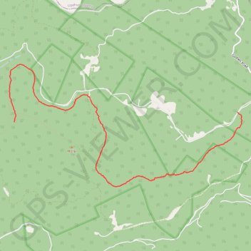
Railroad Grade Trail - Holly River State Park
- Distance: 6.0 mi
- Elevation gain: 1,030 ft
- Maximum elevation: 2,779 ft
- Elevation loss: 561 ft
- Minimum elevation: 2,231 ft
- Moving time: 18 m 14 s
- Moving speed: 19.6 mph
- Maximum speed: 27.8 mph
- Total time: 18 m 14 s
- Global speed: 19.6 mph
Interactive trail map
Trail profile
- Distance: 6.0 mi
- Elevation gain: 1,030 ft
- Maximum elevation: 2,779 ft
- Elevation loss: 561 ft
- Minimum elevation: 2,231 ft
- Moving time: 18 m 14 s
- Moving speed: 19.6 mph
- Maximum speed: 27.8 mph
- Total time: 18 m 14 s
- Global speed: 19.6 mph
About this trail
Name: Railroad Grade Trail - Holly River State Park trail, distance, elevation, map, profile, GPS track
Start: Wilderness Trail, Webster County, West Virginia, United States (38.66317 -80.33053)
End: Baili Ridge Road, Webster County, West Virginia, United States (38.66500 -80.27760)
Coordinates: 38.65116 -80.33174 38.67390 -80.27659
Topography: Webster County topographic map, elevation, terrain