Thank you for supporting this site ❤️
Make a donation
Make a donation
Gear up for your next adventure:
As an Amazon Associate, this site earns from qualifying purchases at no extra cost to you.
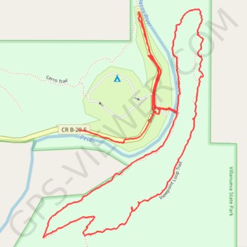
Hike in Villanueva State Park
- Distance: 2.9 mi
- Elevation gain: 479 ft
- Maximum elevation: 6,115 ft
- Elevation loss: 482 ft
- Minimum elevation: 5,745 ft
- Moving time: 1 h 56 m
- Moving speed: 1.5 mph
- Maximum speed: 11.4 mph
- Total time: 5 h 1 m
- Global speed: 0.6 mph
Interactive trail map
Thank you for supporting this site ❤️
Make a donation
Make a donation
Gear up for your next adventure:
As an Amazon Associate, this site earns from qualifying purchases at no extra cost to you.
Trail profile
- Distance: 2.9 mi
- Elevation gain: 479 ft
- Maximum elevation: 6,115 ft
- Elevation loss: 482 ft
- Minimum elevation: 5,745 ft
- Moving time: 1 h 56 m
- Moving speed: 1.5 mph
- Maximum speed: 11.4 mph
- Total time: 5 h 1 m
- Global speed: 0.6 mph
Thank you for supporting this site ❤️
Make a donation
Make a donation
Gear up for your next adventure:
As an Amazon Associate, this site earns from qualifying purchases at no extra cost to you.
About this trail
Name: Hike in Villanueva State Park trail, distance, elevation, map, profile, GPS track
Coordinates: 35.26035 -105.33903 35.26824 -105.33227
Topography: San Miguel County topographic map, elevation, terrain
Thank you for supporting this site ❤️
Make a donation
Make a donation
Gear up for your next adventure:
As an Amazon Associate, this site earns from qualifying purchases at no extra cost to you.