Thank you for supporting this site ❤️
Make a donation
Make a donation
Gear up for your next adventure:
As an Amazon Associate, this site earns from qualifying purchases at no extra cost to you.
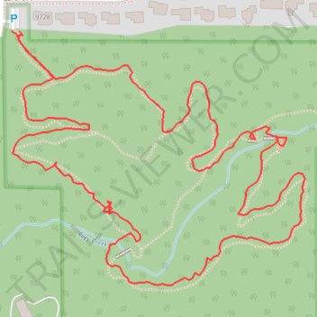
Riley Creek Conservation Area loop walk
- Distance: 1.3 mi
- Elevation gain: 102 ft
- Maximum elevation: 935 ft
- Elevation loss: 102 ft
- Minimum elevation: 866 ft
- Moving time: 39 m 50 s
- Moving speed: 2.0 mph
- Maximum speed: 3.9 mph
- Total time: 43 m 36 s
- Global speed: 1.8 mph
Interactive trail map
Thank you for supporting this site ❤️
Make a donation
Make a donation
Gear up for your next adventure:
As an Amazon Associate, this site earns from qualifying purchases at no extra cost to you.
Trail profile
- Distance: 1.3 mi
- Elevation gain: 102 ft
- Maximum elevation: 935 ft
- Elevation loss: 102 ft
- Minimum elevation: 866 ft
- Moving time: 39 m 50 s
- Moving speed: 2.0 mph
- Maximum speed: 3.9 mph
- Total time: 43 m 36 s
- Global speed: 1.8 mph
Thank you for supporting this site ❤️
Make a donation
Make a donation
Gear up for your next adventure:
As an Amazon Associate, this site earns from qualifying purchases at no extra cost to you.
About this trail
Name: Riley Creek Conservation Area loop walk trail, distance, elevation, map, profile, GPS track
Coordinates: 44.82295 -93.50041 44.82589 -93.49562
Topography: Hennepin County topographic map, elevation, terrain
Thank you for supporting this site ❤️
Make a donation
Make a donation
Gear up for your next adventure:
As an Amazon Associate, this site earns from qualifying purchases at no extra cost to you.