Thank you for supporting this site ❤️
Make a donation
Make a donation
Gear up for your next adventure:
As an Amazon Associate, this site earns from qualifying purchases at no extra cost to you.
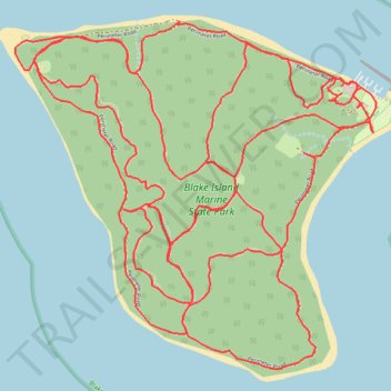
Blake Island Marine State Park trails
- Distance: 11.3 mi
- Elevation gain: 1,909 ft
- Maximum elevation: 266 ft
- Elevation loss: 1,906 ft
- Minimum elevation: 3 ft
- Moving time: 2 h 4 m
- Moving speed: 5.4 mph
- Maximum speed: 16.7 mph
- Total time: 2 h 10 m
- Global speed: 5.2 mph
Interactive trail map
Thank you for supporting this site ❤️
Make a donation
Make a donation
Gear up for your next adventure:
As an Amazon Associate, this site earns from qualifying purchases at no extra cost to you.
Trail profile
- Distance: 11.3 mi
- Elevation gain: 1,909 ft
- Maximum elevation: 266 ft
- Elevation loss: 1,906 ft
- Minimum elevation: 3 ft
- Moving time: 2 h 4 m
- Moving speed: 5.4 mph
- Maximum speed: 16.7 mph
- Total time: 2 h 10 m
- Global speed: 5.2 mph
Thank you for supporting this site ❤️
Make a donation
Make a donation
Gear up for your next adventure:
As an Amazon Associate, this site earns from qualifying purchases at no extra cost to you.
About this trail
Name: Blake Island Marine State Park trails trail, distance, elevation, map, profile, GPS track
Start: Perimeter Road, Kitsap County, Washington, United States (47.54237 -122.48316)
End: Perimeter Road, Kitsap County, Washington, United States (47.54220 -122.48281)
Coordinates: 47.53014 -122.50488 47.54504 -122.48192
Topography: Kitsap County topographic map, elevation, terrain
Thank you for supporting this site ❤️
Make a donation
Make a donation
Gear up for your next adventure:
As an Amazon Associate, this site earns from qualifying purchases at no extra cost to you.