Thank you for supporting this site ❤️
Make a donation
Make a donation
Gear up for your next adventure:
As an Amazon Associate, this site earns from qualifying purchases at no extra cost to you.
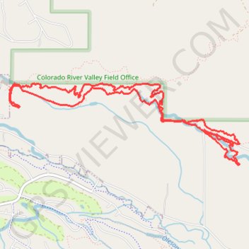
Morning Mountain Bike Ride
- Distance: 5.8 mi
- Elevation gain: 574 ft
- Maximum elevation: 6,972 ft
- Elevation loss: 577 ft
- Minimum elevation: 6,703 ft
- Moving time: 37 m 2 s
- Moving speed: 9.5 mph
- Maximum speed: 22.2 mph
- Total time: 37 m 2 s
- Global speed: 9.5 mph
Interactive trail map
Thank you for supporting this site ❤️
Make a donation
Make a donation
Gear up for your next adventure:
As an Amazon Associate, this site earns from qualifying purchases at no extra cost to you.
Trail profile
- Distance: 5.8 mi
- Elevation gain: 574 ft
- Maximum elevation: 6,972 ft
- Elevation loss: 577 ft
- Minimum elevation: 6,703 ft
- Moving time: 37 m 2 s
- Moving speed: 9.5 mph
- Maximum speed: 22.2 mph
- Total time: 37 m 2 s
- Global speed: 9.5 mph
Thank you for supporting this site ❤️
Make a donation
Make a donation
Gear up for your next adventure:
As an Amazon Associate, this site earns from qualifying purchases at no extra cost to you.
About this trail
Name: Morning Mountain Bike Ride trail, distance, elevation, map, profile, GPS track
Start: Haymaker, Eagle, Eagle County, Colorado, 81631, United States (39.64278 -106.81237)
End: Haymaker, Eagle, Eagle County, Colorado, 81631, United States (39.64279 -106.81240)
Coordinates: 39.63491 -106.81383 39.64310 -106.78395
Topography: Eagle County topographic map, elevation, terrain
Thank you for supporting this site ❤️
Make a donation
Make a donation
Gear up for your next adventure:
As an Amazon Associate, this site earns from qualifying purchases at no extra cost to you.