Thank you for supporting this site ❤️
Make a donation
Make a donation
Gear up for your next adventure:
As an Amazon Associate, this site earns from qualifying purchases at no extra cost to you.
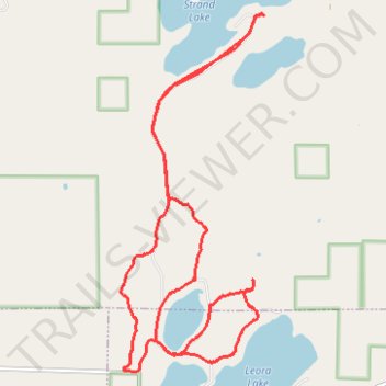
Rose Lake Trails
- Distance: 9.7 mi
- Elevation gain: 328 ft
- Maximum elevation: 1,440 ft
- Elevation loss: 325 ft
- Minimum elevation: 1,378 ft
Interactive trail map
Thank you for supporting this site ❤️
Make a donation
Make a donation
Gear up for your next adventure:
As an Amazon Associate, this site earns from qualifying purchases at no extra cost to you.
Trail profile
- Distance: 9.7 mi
- Elevation gain: 328 ft
- Maximum elevation: 1,440 ft
- Elevation loss: 325 ft
- Minimum elevation: 1,378 ft
Thank you for supporting this site ❤️
Make a donation
Make a donation
Gear up for your next adventure:
As an Amazon Associate, this site earns from qualifying purchases at no extra cost to you.
About this trail
Name: Rose Lake Trails trail, distance, elevation, map, profile, GPS track
Coordinates: 47.10413 -92.42662 47.14334 -92.40338
Topography: Whiteface Reservoir topographic map, elevation, terrain
Thank you for supporting this site ❤️
Make a donation
Make a donation
Gear up for your next adventure:
As an Amazon Associate, this site earns from qualifying purchases at no extra cost to you.